The Lakes Homes for Sale
A planned community in west Las Vegas, about two square miles around the 30-acre Lake Sahara.
Life in The Lakes
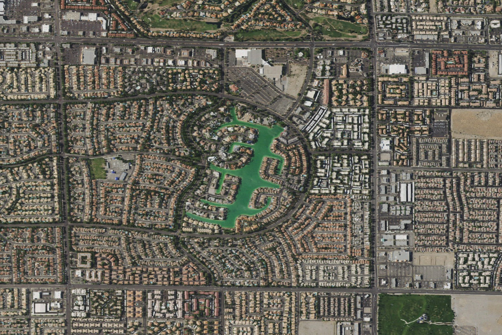
One Lake on the West Side of Las Vegas
The Lakes is a planned community in the western Las Vegas Valley, inside the city limits of Las Vegas. It covers about two square miles and was built from the mid-1980s into the mid-1990s, when this side of the valley was still the edge of development. The centerpiece is Lake Sahara, a man-made lake. The plan called for two lakes. One was built. This guide sits under the Las Vegas hub. The map marker is the published coordinate for the community, on Lake Sahara. It marks the lake, not a surveyed line around every house.
The Review-Journal places the original development between Durango Drive on the east and Hualapai Way on the west, and between Desert Inn Road on the south and Sahara Avenue on the north. The builders were Al and Marty Collins, with Russ Dorn and financier Ken Sullivan. As the project grew, the idea of several lakes became one lake of 30 acres, with tributaries. They named it Lake Sahara because it sits by the Sahara Avenue extension. The same account describes several large ponds between Fort Apache Road and Hualapai Way. Those ponds are not the 30-acre lake.
The houses are not one product. Six communities first bordered Lake Sahara, each with gated access from Crystal Water Way and Lake East Drive. The east side of the lake was set aside for production homes. The south side included townhomes and condominiums in separate communities. The west and northwest sides, Beach View and Coast Line, were reserved for custom homes. The Review-Journal describes those waterfront custom sites as one-third of an acre running to the water. That lot size is about those sites, not about every parcel in the two square miles. Apartments, production homes, and custom homes filled in between Durango and Hualapai. A gate on one of the six is not a gate on the next street. Confirm how visitors get to the house you are touring.
In a 2016 oral history for the UNLV University Libraries, builder Larry Canarelli called The Lakes a leapfrog project, about two miles west of where the pavement then ended at West Sahara Avenue and Rainbow Boulevard. He said that in 1984 there were only scattered desert houses west of Jones Boulevard, that the Collins brothers paved Sahara for two miles west of Rainbow, and that in 1985 that road was a narrow two lanes and the only way in. He recalled about 7,000 or 8,000 home sites by final approval, plus apartment sites. That number is his recollection of the approval. It is not a count of homes for sale, and this page does not publish a current total.
The name on a piece of bank mail is a different fact from the name of the neighborhood. Vegas Inc reported that the Collins brothers owned the desert ground at Sahara and Durango where Citicorp built a credit-card processing center. The company broke ground in September 1984 and opened in April 1985. The original center was described as roughly $8 million and 120,000 square feet, planned for 1,000 employees. In 1987 Citicorp announced a $13.5 million office building beside the first. The campus address published later is 8725 W. Sahara Avenue. Citicorp mailed from “The Lakes, NV.” Vegas Inc, citing a March 1985 Wall Street Journal report, said the company had obtained U.S. Postal Service permission for that name. A local spokeswoman said in 1996 that the choice was a marketing decision for the development. The bank later moved the campus to mortgage processing and closed it in 2014. Vegas Inc photographed the empty building in March 2015. House mail reads Las Vegas. Desert Shores, to the northwest, and Lake Las Vegas, in Henderson, were separate lake projects. A listing in either one is not a listing here. Summerlin is the master plan to the west.
Curious About Life in The Lakes?
Talk to the Crighton Rinaldi Team — no pressure, just answers.
Contact the Team(725) 210-0333Where Community Meets Daily Life
The plan started with more than one lake. What was built is Lake Sahara, 30 acres, with tributaries, beside the Sahara Avenue extension. Ponds between Fort Apache and Hualapai are a separate feature.
Production homes on the east side of the lake, townhomes and condominiums on the south, and custom homes in Beach View and Coast Line on the west and northwest. The one-third-acre figure is the Review-Journal’s description of those waterfront custom sites.
Desert Shores is a separate lake community to the northwest. Summerlin is the master plan to the west. Lake Las Vegas is in Henderson. The search on this page is The Lakes.
The credit-card center opened in April 1985 at 8725 W. Sahara Avenue and closed in 2014. A 728-unit proposal on that land was tabled on November 10, 2026. It is not an approved home and not a house on the lake.
The Lakes Home Prices
The Lakes is a resale community: production houses, townhomes, condominiums, custom homes, and apartments inside the same two square miles, some on Lake Sahara and some not. This page does not publish a median or a price tier. Canarelli’s 7,000 or 8,000 is a recollection of home sites at approval, not current inventory. The 728 units in case 26-0401-SDR1 are an application that was tabled on November 10, 2026, not homes for sale. Use the listings below for what is filed under The Lakes today. Ask which section the house is in, whether that street is one of the six that faced the lake, whether the lot touches the water, and which association assesses it.
An Exceptional Daily Life
30 acres, man-made, with tributaries, named for the Sahara Avenue extension. The Review-Journal described docks and electric and sail boats at houses on the water. This page does not publish boating rules. Ask the association for the lot.
Six communities first bordered Lake Sahara, with access from Crystal Water Way and Lake East Drive. The rest of the two square miles includes streets that were not those six. Confirm the house.
Named in the Review-Journal as part of the original development plan. The school publishes 9001 Mariner Cove Drive, Las Vegas, NV 89117, and (702) 799-4390. Assignment is by street address.
8725 W. Sahara Avenue. Opened April 1985. Closed in 2014. A later proposal for 728 units on the 28.07-acre site was tabled by the Planning Commission on November 10, 2026.
Schools Serving The Lakes
| School | Grades | District |
|---|---|---|
| M.J. Christensen Elementary School | Elementary | Clark County School District |
School assignments are based on address and subject to change. Verify current zoning and enrollment directly with the Clark County School District (CCSD) or the applicable school before purchasing.
Ask About The Lakes Schools & Amenities
Talk to the Crighton Rinaldi Team — no pressure, just answers.
Contact the Team(725) 210-0333History & Development
The Review-Journal’s account starts in 1985, when the west boundary of Las Vegas still ended at Rainbow Boulevard and the land farther west was desert. The Collins brothers, Dorn, and Sullivan planned homes around water. Vegas Inc, writing in 2015, said the same developers were planning homes around two man-made lakes and built one, and that the plural name stayed. Canarelli’s 2016 interview is the account of the road: Sahara paved west from Rainbow, and a two-lane road as the way in during 1985.
The campus at the corner came with the houses, and then it left. Gov. Richard Bryan called a special session that met on March 29, 1984, and signed Senate Bill 2 the next day, changing state banking law so Citicorp could open the center. Groundbreaking followed that September. The doors opened in April 1985. The 1987 expansion was a second building, not a second lake. Operations later shifted to mortgages. In September 2013 the company said it would cut about 1,000 home-lending jobs, most of them in Las Vegas. In January 2014 it told about 220 employees at the campus that the jobs would end by October or become work from home. About 60 were slated to telecommute. By March 2015 the building was vacant and listed for rent.
What happens to that campus is not a resale on the lake. On November 6, 2026, NVBEX reported that Calida Group had asked the Las Vegas Planning Commission to review a mixed-use plan on the 28.07-acre site at the southeast corner of Sahara Avenue and Crystal Water Way: 728 residential units and about 34,600 square feet of commercial space, in place of a campus NVBEX measured at about 309,100 square feet. The case is 26-0401-SDR1. A record of the November 10, 2026 commission lists the item as tabled, 6–0. A meeting log of the same day says it was held to December 8, 2026, at the applicant’s request, and that no hearing was held. Those are not the city minutes. They agree on the point that matters for a buyer: the 728 units are not approved, and they are not The Lakes homes for sale.
The two-square-mile description, the city-limits location, the single lake, and the mid-1980s to mid-1990s build-out are in the Wikipedia article on The Lakes. Boundaries, the 30 acres, the developers, the six gated sections, Beach View, Coast Line, and M.J. Christensen Elementary as part of the original plan are in the Review-Journal feature on The Lakes. The road and the home-site recollection are in the UNLV Libraries oral history with Larry Canarelli. The campus, the postal name, and the 2014 closing are in Eli Segall’s March 17, 2015 Vegas Inc article. The 2026 application is in the NVBEX report of November 6, 2026, the November 10 tabling record, and the meeting log that places the hold on December 8. The aerial is U.S. Geological Survey imagery from The National Map.
Access & Transportation
Orient a showing from the four edges the Review-Journal names: Sahara Avenue, Durango Drive, Desert Inn Road, and Hualapai Way. Fort Apache Road crosses the plan. The 215 is the regional route to the west of Hualapai. Harry Reid International Airport is the valley’s commercial airport. This page does not quote a drive time. The former campus is at 8725 W. Sahara Avenue, near Durango. M.J. Christensen Elementary School publishes its campus at 9001 Mariner Cove Drive, Las Vegas, NV 89117. Confirm the ZIP on the house.
Mail for the houses reads Las Vegas. “The Lakes, Nevada” was the postal name Citicorp used, not a separate city. In 1985 the municipal line was still at Rainbow, and the plan was built west of it. Wikipedia describes the community today as inside the Las Vegas city limits. The six sections that first faced the lake were reached from Crystal Water Way and Lake East Drive. Streets farther from the water were a different product, including apartments and production homes. The aerial is centered on the lake and also shows Sahara Avenue, commercial buildings, and the golf course north of Sahara, which is not Lake Sahara and not this plan.
The Lakes, Las Vegas NV
The Lakes · Las Vegas, NV
Homes in The Lakes
Homes for Sale
No active listings matching The Lakes? Explore homes in the surrounding area or contact us for upcoming, private, or off-market opportunities.
Nearby Communities
Frequently Asked Questions
In west Las Vegas, inside the city limits. The Review-Journal places the original plan between Sahara Avenue, Durango Drive, Desert Inn Road, and Hualapai Way, about two square miles. The map on this page marks Lake Sahara. In 1985 the city’s west line was still at Rainbow Boulevard, and the plan was built beyond it. Mailing addresses read Las Vegas. The elementary school publishes 89117. Confirm the ZIP on the house.
No. Desert Shores is a separate master-planned lake community to the northwest, with its own association. Lake Las Vegas is in Henderson. Summerlin is the master plan west of Hualapai Way. Vegas Inc described those lake projects as separate from The Lakes. Use the listings on this page for The Lakes only.
The Review-Journal described private docks and electric and sail boats at houses on the 30-acre lake. It did not publish the association rules, and this page does not either. Six communities first bordered the lake, with gated access. Ask the association for the specific lot before you assume a dock, a boat, or a gate.
M.J. Christensen Elementary School was part of the original development plan. Its campus is at 9001 Mariner Cove Drive, Las Vegas, NV 89117. Middle school and high school zones are assigned by street address and are not one assignment for a plan this large. Confirm the house in the Clark County School District zoning search.
Citicorp opened the credit-card center at 8725 W. Sahara Avenue in April 1985 and closed the campus in 2014. In November 2026 Calida Group had a site-plan application, case 26-0401-SDR1, for 728 units and about 34,600 square feet of commercial space on the 28.07-acre site. The Planning Commission tabled it on November 10, 2026. A meeting log says the item returns December 8, 2026. It is not approved housing, and it is not a listing on the lake.
The listings module on this page shows current matches filed under The Lakes. Inventory changes daily. A future unit on the old campus is a different application. For a house that is not on the open market, or for gate and association details on a specific street, contact the Crighton Rinaldi Team.
Let's Talk About The Lakes
The Crighton Rinaldi Team has deep expertise in The Lakes and the surrounding Las Vegas area.
Get in Touch About The Lakes
Fill out the form and one of our agents will be in touch shortly.